

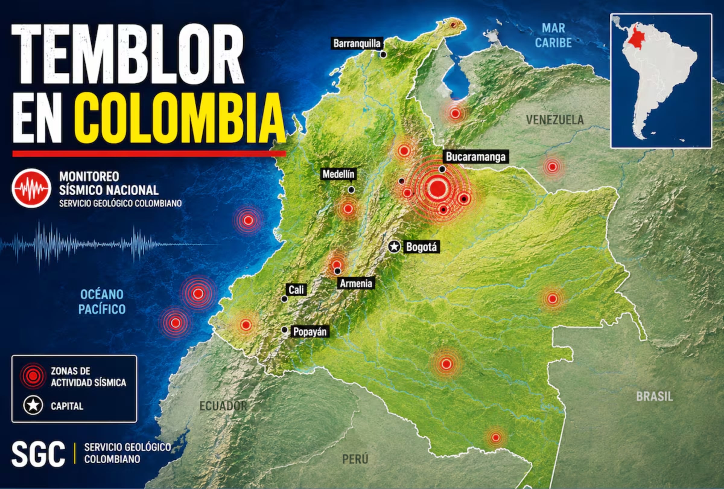
The Colombian Geological Service recorded a series of six minor earthquakes across the country late Tuesday, September 29, 2026, including a 3.8 magnitude tremor in the Choco department.
The national seismological network monitored the sequence of tremors, which primarily affected the Tolima region. The agency notes that its initial automated parameters are preliminary and subject to revision as data is processed.
Choco and Antioquia tremors
The strongest of the evening's earthquakes struck at 8:38 p.m. local time in Istmina, Choco. The SGC manually evaluated the 3.8 magnitude tremor, which originated at a depth of 40 kilometres at coordinates 4.51, -76.74.
The epicentre was located 20 kilometres from Sipi, 52 kilometres from Novita and 56 kilometres from El Dovio.
Earlier in the evening, a 2.2 magnitude earthquake was registered at 7:43 p.m. in Dabeiba, Antioquia. The superficial tremor was also manually processed, with coordinates of 6.82, -76.28. It occurred 15 kilometres from Uramita, 18 kilometres from Frontino and 20 kilometres from Dabeiba.
Tolima earthquake sequence
The agency's automated systems recorded four separate superficial tremors in the Tolima department between 8:33 p.m. and 10:47 p.m.
A 2.0 magnitude movement hit San Antonio at 8:33 p.m. The epicentre was seven kilometres from San Antonio, 11 kilometres from Roncesvalles and 25 kilometres from Chaparral.
Three subsequent quakes were centred in Chaparral. A 2.0 magnitude tremor occurred at 9:07 p.m., located 20 kilometres from San Antonio, 21 kilometres from Roncesvalles and 22 kilometres from Chaparral.
A 2.1 magnitude movement followed at 9:54 p.m., positioned 25 kilometres from Rioblanco, 28 kilometres from Chaparral and 34 kilometres from Roncesvalles.
The final 2.1 magnitude tremor struck at 10:47 p.m. It was recorded 20 kilometres from Rioblanco, 26 kilometres from Chaparral and 36 kilometres from San Antonio.
Colombia tectonic activity
Colombia sits in a highly active seismic region where the Nazca, South American and Caribbean tectonic plates interact. Earthquakes occur in both subduction zones and geological faults within the crust, meaning they are not concentrated in a single region.
The country has numerous fault systems associated with the deformation of the Andes, including the Bucaramanga Santa Marta, Romeral and Algeciras faults. These structures allow accumulated energy in the earth's crust to be released.
Seismic risk varies across the nation. The Bucaramanga Seismic Nest in the Santander department is one of the most active zones, known for a high frequency of small tremors that often go unnoticed by the population. Monitoring this area helps researchers study the depth, frequency and distribution of events.
The southwest of the country, near the Pacific coast and the Ecuador border, also experiences significant activity. Tremors are frequently recorded in the eastern foothills and the departments of Meta, Cundinamarca, Boyaca and Tolima.
Historical earthquakes and aftershocks
Colombia has a history of destructive earthquakes. The 1906 Tumaco earthquake remains one of the largest recorded in the country's history.
In 1983, a tremor in Popayan caused severe damage and significant consequences for its residents. Another devastating event struck the Eje Cafetero region in 1999, heavily affecting Armenia and surrounding localities.
More recently, a 6.1 magnitude earthquake hit near El Calvario, Meta, at 12:04 p.m. on August 17, 2023. The tremor had a superficial depth of less than 30 kilometres and was felt across different departments.
The agency documented a major aftershock sequence following the El Calvario event. By 2:00 p.m. that day, more than 20 aftershocks between 2.0 and 5.6 in magnitude had been reported. By 6:00 p.m. on August 18, the SGC had located 180 associated earthquakes with magnitudes ranging from 0.7 to 6.1 and depths under 20 kilometres. Aftershocks can continue for days, weeks or months following a main earthquake.
Monitoring and safety
The National Seismological Network of Colombia continuously evaluates the country's seismic activity, using its data to calculate the origin time, magnitude, depth and epicentre location of each event. Citizens can use the official earthquake viewer and report what they felt through the agency's Sismo Sentido form.
The SGC uses the European Macroseismic Scale EMS 98 to evaluate earthquake intensity. While magnitude measures the size of a quake at its origin, intensity describes its effects at a specific location. A shallow tremor might cause strong shaking near the epicentre, while a deeper quake could be felt across a wider area without producing the same surface impact. Characteristics of the local terrain and distance from the epicentre also influence how a quake is felt.
Authorities advise residents to take precautionary measures before an earthquake strikes. Recommended steps include:
- Preparing an emergency backpack containing water, food, a flashlight, a first aid kit and basic supplies.
- Establishing a family plan with designated meeting points.
- Securing heavy furniture, shelves and objects that could fall.
- Identifying safe places in homes, offices or schools.
- Reviewing evacuation routes and available exits.
During an earthquake, people should drop, cover and hold on. Those indoors should seek protection under a sturdy table, protect their head and neck, and stay away from glass, windows and shelves. Evacuating during the shaking or using elevators is not recommended.
People outdoors should move away from buildings, poles and cables. Drivers are advised to stop in a safe place and remain in their vehicles until the shaking stops.
After an event, residents should check for injuries and structural damage, including gas leaks and electrical issues. Affected buildings should not be entered until cleared by authorities.
The SGC notes that science cannot predict the exact date, time, location and magnitude of an earthquake in advance, making preparation the primary tool for reducing risk.


