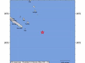
A magnitude 7.7 earthquake has shaken this Friday the southeast of the Loyalty Islands, an archipelago of the French territory of New Caledonia, in the South Pacific, activating a tsunami warning within a radius of 1,000 kilometers.
The Pacific Tsunami Warning Service has indicated that “the dangerous waves are possible on the coasts within a radius of 1000 kilometers” around the epicenter, which could have between one and three meters high in its impact against the coasts of Vanuatu and between 0.3 and one meter in Fiji, Kiribati and New Zealand.
The United States Geological Survey (USGS), which monitors global seismic activity, has located the earthquake at a depth of 37 kilometers under the seabed and 333 kilometers southeast of the town of Vao, on the Isle of Pines -the southernmost in New Caledonia- and 433 kilometers southeast of Isangel, on the island of Tanna in Vanuatu.
For its part, the Australian Meteorological Service has indicated that tsunami could threaten Lord Howe Island, more than 450 kilometers east of the eastern town of Port Macquarie, in the State of New South Wales. In turn, the New Zealand National Emergency Management Agency has indicated on social networks that “assess” the potential threat.
New Caledonia is located near the so-called Pacific Ring of Fire and the submarine volcanoes of the Lau Basin, which is why it regularly registers shocks of seismic origin.
Source: Lasexta
Ricardo is a renowned author and journalist, known for his exceptional writing on top-news stories. He currently works as a writer at the 247 News Agency, where he is known for his ability to deliver breaking news and insightful analysis on the most pressing issues of the day.


